MAPIFYSTATS / DISASTERS & EXTREME WEATHER

Every place has a weather history.

Follow documented storms, flood reports and earthquakes through place and time.

Your place’s disaster history
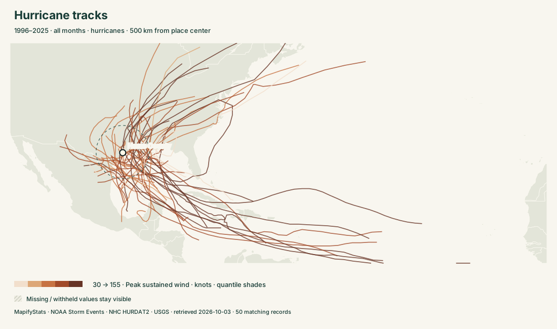
Hurricane tracks; exact records and sources in the explorer
NOAA Storm Events · NHC HURDAT2 · USGS · historical records through 2025
1,759,371NOAA reports3,250storm histories381,035earthquakes

SIX WAYS INTO THE ATLAS

Start with a question.

Choose a place. Read the record. Take the map with you.

04

Flood history

Explore flash, river and coastal flood reports and their documented impacts.

↗

PLACES & STORIES

Go deeper.

176 substantive profiles. Every covered place remains searchable in the explorers.

Delaware →District of Columbia →Florida →Georgia →Hawaii →Idaho →Illinois →Indiana →Iowa →Kansas →Kentucky →Louisiana →Maine →Maryland →Massachusetts →Michigan →Minnesota →Mississippi →Missouri →Montana →Nebraska →Nevada →New Hampshire →New Jersey →New Mexico →New York →North Carolina →North Dakota →Ohio →Oklahoma →Oregon →Pennsylvania →Rhode Island →South Carolina →South Dakota →Tennessee →Texas →Utah →Vermont →Virginia →Washington →West Virginia →Wisconsin →Wyoming →Alabama →Alaska →Arizona →Arkansas →California →Colorado →Connecticut →Maricopa County, AZ →Sedgwick County, KS →El Paso County, CO →Cook County, IL →Tarrant County, TX →Allegheny County, PA →Pennington County, SD →Polk County, IA →Tulsa County, OK →Greene County, MO →Madison County, AL →Lauderdale County, AL →Oklahoma County, OK →San Bernardino County, CA →Lincoln County, NE →Butler County, KS →Duval County, FL →Ford County, KS →Pima County, AZ →Montgomery County, MD →Westmoreland County, PA →Harris County, TX →Pulaski County, AR →Weld County, CO →Meade County, SD →Yuma County, CO →Fairfax County, VA →Davidson County, TN →Caddo Parish, LA →Wake County, NC →Dallas County, TX →Denton County, TX →Cherry County, NE →Laramie County, WY →Cleveland County, OK →Richland County, SC →Colbert County, AL →Randall County, TX →Baltimore County, MD →Jackson County, MO →Berks County, PA →Charleston County, SC →Kit Carson County, CO →Potter County, TX →Cowley County, KS →Chester County, PA →Sherman County, KS →Bexar County, TX →Leon County, FL →Valley County, MT →Reno County, KS →Rankin County, MS →St. Louis County, MO →Colleton County, SC →Jefferson County, AL →Hinds County, MS →Worcester County, MA →St. Louis County, MN →Lexington County, SC →San Diego County, CA →Mohave County, AZ →Will County, IL →Custer County, NE →Shawnee County, KS →Osage County, OK →Collin County, TX →Middlesex County, MA →Miami-Dade County, FL →Hennepin County, MN →Tom Green County, TX →Finney County, KS →Johnson County, KS →Burlington County, NJ →Le Flore County, OK →Story County, IA →Jefferson County, KY →Loudoun County, VA →Montgomery County, PA →Linn County, IA →Campbell County, WY →Dane County, WI →Comanche County, OK →Broward County, FL →Frederick County, MD →Greenville County, SC →Hawaii County, HI →Broome County, NY →Minnehaha County, SD →Morgan County, AL →Benton County, AR →Washington County, CO →Barton County, KS →Honolulu County, HI →Otter Tail County, MN →Custer County, SD →Washington County, PA →Saratoga County, NY →Barry County, MO →Cass County, ND →Horry County, SC →Patricia · 2015 →Melissa · 2025 →Dorian · 2019 →Wilma · 2005 →Paka · 1997 →Linda · 1997 →Irma · 2017 →Mitch · 1998 →Milton · 2024 →Rita · 2005 →Rick · 2009 →Dean · 2007 →Felix · 2007 →Katrina · 2005 →Maria · 2017 →Beryl · 2024 →Ivan · 2004 →Isabel · 2003 →Lee · 2023 →Matthew · 2016 →Kenna · 2002 →Otis · 2023 →Emily · 2005 →Erin · 2025 →Humberto · 2025 →

READ THE RECORD

Sources, coverage & definitions

NOAA Storm Events · NHC HURDAT2 · USGS · retrieved 2026-10-03

NOAA weather coverage uses 1996–2025 for general event types, with tornado histories back to 1950. County (C) and forecast-zone (Z) records stay separate. County comparisons count only county-assigned reports; state histories also include forecast zones. A report count measures documentation, not a probability of future loss. Narrative text is excerpted at 1,600 characters; original records remain linked.

Radius searches include only records with usable positions, and tornado distance uses the reported endpoint segment. No missing location is invented. Some NOAA reported start dates differ from their annual source file; the reported date is retained. Property/crop damage is nominal source-year dollars. Missing estimates differ from zero; totals must be read with reporting coverage.

NHC tracks show storm centers and recorded fixes, not swaths of damage. Closest approach uses great-circle segments between fixes. Landfalls count L-marked fixes. USGS earthquakes cover magnitude 2.5+ within longitude −180 to −60, latitude 15 to 75, 1970–2025; this includes neighboring countries and offshore events. Historical completeness and preferred magnitudes vary. No live warnings are provided.

NOAA Storm Events · NHC HURDAT2 · USGS catalog · Existing county hail resource →

Download provenance, source URLs and SHA-256 hashes ↓