MAPIFYSTATS / FOOD & AGRICULTURE

Meet the places that feed us.

Explore crops, livestock and the agricultural regions behind your ingredients.

Map your meal
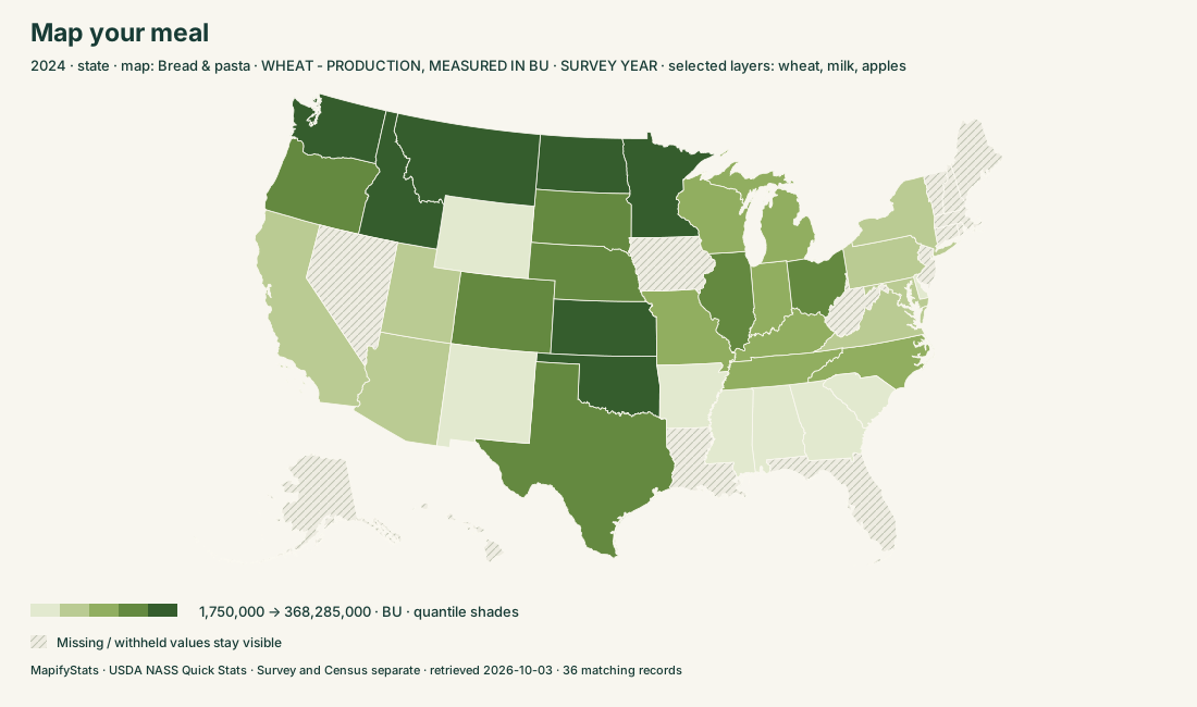
Map your meal; exact records and sources in the explorer
USDA NASS Quick Stats · Survey and Census separate · historical records through 2025
393source measures622,168published records15ingredients

SIX WAYS INTO THE ATLAS

Start with a question.

Choose a place. Read the record. Take the map with you.

02

Crop atlas

Compare reported acreage, production and yield by commodity and year.

↗

PLACES & STORIES

Go deeper.

165 substantive profiles. Every covered place remains searchable in the explorers.

LOUISIANA →COLORADO →MINNESOTA →GEORGIA →NEW MEXICO →WASHINGTON →MICHIGAN →KANSAS →NEBRASKA →CALIFORNIA →OKLAHOMA →MISSISSIPPI →FLORIDA →WEST VIRGINIA →NORTH CAROLINA →UTAH →NEW YORK →TEXAS →IOWA →INDIANA →OHIO →NEW JERSEY →WYOMING →WISCONSIN →ILLINOIS →DELAWARE →ALABAMA →ARKANSAS →MARYLAND →OREGON →PENNSYLVANIA →IDAHO →MISSOURI →VIRGINIA →NORTH DAKOTA →TENNESSEE →MAINE →MONTANA →SOUTH DAKOTA →KENTUCKY →SOUTH CAROLINA →ARIZONA →RHODE ISLAND →VERMONT →MASSACHUSETTS →CONNECTICUT →NEW HAMPSHIRE →NEVADA →ALASKA →HAWAII →Chouteau County, MT →Hill County, MT →Fresno County, CA →Kern County, CA →Polk County, MN →Whitman County, WA →Stutsman County, ND →Cass County, ND →Kit Carson County, CO →Toole County, MT →Weld County, CO →Ward County, ND →Bottineau County, ND →Brown County, SD →Washington County, CO →Cavalier County, ND →Grant County, WA →Williams County, ND →Marshall County, MN →Lincoln County, WA →McLean County, ND →Barnes County, ND →Adams County, WA →Tulare County, CA →Richland County, ND →Roosevelt County, MT →Spink County, SD →Valley County, MT →Sheridan County, MT →Umatilla County, OR →Imperial County, CA →Kiowa County, CO →Liberty County, MT →Finney County, KS →Grand Forks County, ND →Baca County, CO →Walsh County, ND →Texas County, OK →Mountrail County, ND →Sumner County, KS →Holt County, NE →Yuma County, CO →Gaines County, TX →Wells County, ND →Iroquois County, IL →Lincoln County, CO →Fergus County, MT →San Joaquin County, CA →Reno County, KS →McHenry County, ND →LaMoure County, ND →Renville County, MN →Hand County, SD →Pembina County, ND →Walla Walla County, WA →Livingston County, IL →Custer County, NE →Ramsey County, ND →McLean County, IL →LaSalle County, IL →Morton County, ND →Kossuth County, IA →Logan County, CO →Sherman County, KS →Edmunds County, SD →Merced County, CA →Emmons County, ND →Cheyenne County, NE →Otter Tail County, MN →Deaf Smith County, TX →Hettinger County, ND →Ford County, KS →Redwood County, MN →Champaign County, IL →Thomas County, KS →Cheyenne County, CO →McKenzie County, ND →Traill County, ND →Kittson County, MN →Teton County, MT →Stearns County, MN →McCone County, MT →Mississippi County, AR →Clay County, MN →Pottawattamie County, IA →Douglas County, WA →Towner County, ND →Benson County, ND →Pondera County, MT →Divide County, ND →Morrow County, OR →Daniels County, MT →Terry County, TX →Hamilton County, KS →Dickey County, ND →Kidder County, ND →Stark County, ND →Plymouth County, IA →Nelson County, ND →Renville County, ND →Corn · producing regions →Bread & pasta · producing regions →Rice · producing regions →Potatoes · producing regions →Tomatoes · producing regions →Apples · producing regions →Grapes · producing regions →Oranges · producing regions →Peanuts · producing regions →Soybeans · producing regions →Milk & cheese · producing regions →Eggs · producing regions →Chicken · producing regions →Beef · producing regions →Pork · producing regions →

READ THE RECORD

Sources, coverage & definitions

USDA NASS Quick Stats · Survey and Census separate · retrieved 2026-10-03

USDA NASS Quick Stats survey observations cover 2019–2025; Census of Agriculture records cover 2017 and 2022. Annual TOTAL-domain whole-product measures are reviewed for this launch. Class, production/utilization practice, reference period, program and units form an exact measure identity. Forecast periods, overlapping size/domain subtotals and organic subsets are excluded. Some market-specific products remain separately labeled.

(D) means withheld, (Z) means below the source publication threshold, and unavailable values remain separate from recorded zero. Suppressed values are never reconstructed. Official state totals are independent of county records. Combined or historic county entities preserve their source identity and may have no map point. Crop production and livestock inventory are different measures; units across ingredient layers are never added. Missing selected years are not filled from another year.

Ingredient maps explain producing regions, not the origin of a particular purchased food. County production is unavailable for some ingredients; use official state totals. Specialization shows each product’s share of an independently published official state/national total; a missing denominator stays unavailable. Farmland changes compare the same Census measure in 2017 and 2022; a zero baseline has no percentage change.

USDA Quick Stats bulk datasets · 2022 Census of Agriculture

Download provenance, source URLs and SHA-256 hashes ↓