
MAPIFYSTATS / ANIMATED MAPS / 09
Budapest / Buda, Pest: History Beneath Your Feet
One place. A succession of documented borders. Inspect reviewed political milestones, their source geometry and the uncertainty around changing boundaries.
Historical polygons by André Ourednik and historical-basemaps contributors, GPL-3.0. Cropped, topology-repaired and simplified by MapifyStats. 1783 entity name corrected. Source geometry and GPL license are included. · Source release, rights & limitations
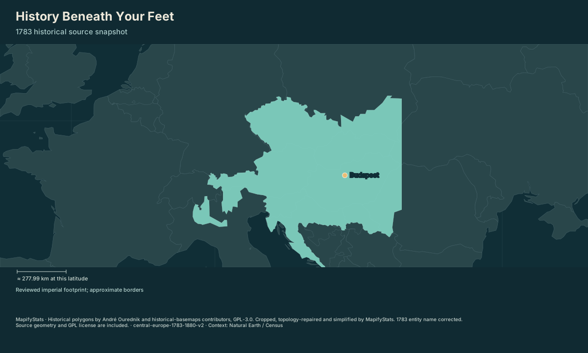
Budapest at the 1783 source snapshot: Habsburg hereditary lands. This is the selected entity’s generalized footprint.
| Place / record | Value | Definition |
|---|---|---|
| Budapest | Habsburg hereditary lands |
The opening frame and source values work without JavaScript. Enable JavaScript to play, select places, compare or export.
Historical polygons by André Ourednik and historical-basemaps contributors, GPL-3.0. Cropped, topology-repaired and simplified by MapifyStats. 1783 entity name corrected. Source geometry and GPL license are included. · Source release, rights & limitations
Vienna is fixed on the map. The 1783 outline is a generalized view of Habsburg lands, not a complete map of Holy Roman institutions.
Historical polygons by André Ourednik and historical-basemaps contributors, GPL-3.0. Cropped, topology-repaired and simplified by MapifyStats. 1783 entity name corrected. Source geometry and GPL license are included. · Source release, rights & limitations
Synchronized comparison
Both maps share replay progress and geographic scale. Source periods appear in each title.
What the map shows
Budapest at the 1783 source snapshot: Habsburg hereditary lands. This is the selected entity’s generalized footprint.
Drag to explore; manual map movement releases guided following. Particle movement and travel progress are illustrative. Attribution stays with every exported image.
Share this replay
Links include your selected public places, time, camera and exact source version. Review your selections before sharing.
Browser video recording is best effort, at 12 fps. A poster remains available when video capture is unsupported.
Accessible source values
| Place / record | Value | Definition |
|---|---|---|
| Budapest | Habsburg hereditary lands |
Accessible comparison values
Sources, rights & limitations
Historical polygons by André Ourednik and historical-basemaps contributors, GPL-3.0. Cropped, topology-repaired and simplified by MapifyStats. 1783 entity name corrected. Source geometry and GPL license are included. Basemap: Natural Earth (public domain), U.S. Census Bureau/us-atlas (public domain). Ancient Earth uses the reconstructed source-model land instead.
Data release: central-europe-1783-1880-v2. Retrieved 2026-10-04. Commercial use: approved. Export rights: approved-with-GPL-and-attribution.
- https://raw.githubusercontent.com/aourednik/historical-basemaps/da7a4b735ecef70aebdc9c73e409d8a2500d50f3/geojson/world_1783.geojson
- https://raw.githubusercontent.com/aourednik/historical-basemaps/da7a4b735ecef70aebdc9c73e409d8a2500d50f3/geojson/world_1815.geojson
- https://raw.githubusercontent.com/aourednik/historical-basemaps/da7a4b735ecef70aebdc9c73e409d8a2500d50f3/geojson/world_1880.geojson
- https://www.austria.org/history-2
- https://www.austria.info/de-at/portraits/habsburger/
- https://www.habsburger.net/en/chapter/war-over-italy
- https://www.wien.gv.at/pdf/ma23/viennainfigures-2022.pdf
- https://www.lombardiabeniculturali.it/istituzioni/schede/8000359/
- https://ww1.habsburger.net/en/chapters/dual-monarchy-two-states-single-empire
- Coverage is limited to one selected entity in Central Europe at 1783, 1815 and 1880. Outside the entity means outside reviewed coverage, not ungoverned territory.
- Generalized GPL source polygons are cropped to this chapter. Their precision cannot establish parcel-level jurisdiction or contested local frontiers.
- Borders crossfade only as a visual transition; no intermediate year, event date or morphing frontier is asserted.
- The 1783 source label Austrian Empire is corrected to Habsburg hereditary lands, since the empire was created in 1804.
- This is a source-based editorial check, not an independent historian's review. Internal crownland boundaries, local minority histories and overlapping Holy Roman institutions need further chapters.
Units: epoch: source year · geometry: longitude, latitude degrees.
Immutable manifest and asset checksums · Download normalized source scene